It’s Turning into a “BEAST”

Well, you know…when you have extra time to plan and survey the route…sometimes your initial ideas can get away from you!

Original plan was to traverse the Continental Divide from Grays Peak and then “hop” over to Long’s Peak. Well, I was thinking that I might want to do another route and hit some more peaks along the way.

So, I am planning on starting from Summit Lake near Evans, heading over to Mount Bierstadt via the West Ridge Route (B2), hiking over to Square Top Mountain, Mount Edwards, and then on to Grays.

This takes the total mileage to around 93 miles. I am planning on 13 to 15 miles per day.

Advertisement

Note About the Route…

An invaluable resource for the route is Gerry Roach’s Colorado’s Indian Peaks: Classic Hikes and Climbs. He notes that there are some obstacles to hiking the divide, and I want to list them here. I will add more later about tackling these obstacles.

There are several technical obstacles to traversing right on the crest of the Continental Divide. From south to north, they are: Neva’s north ridge, South Arapaho’s southwest face, North Arapaho’s northeast ridge, north ridge of “Deshawa,” Arikaree’s northwest ridge, Paiute’s northwest ridge, Isolation’s north ridge and McHenrys Notch.”

(Indian Peaks, p. 155)
Neva’s North Ridge

Header Image:
https://www.coloradoswildareas.com/wp-content/uploads/2011/02/indian-pano.jpg

The Route

The map shows the general route of the modified Pfiffner I will be hiking. Basically, the route starts at Gray’s Peak and follows the Continental Divide (not the trail) for a majority of the route and then heads towards Long’s peak.

The route is around 93 miles.

Starting at Summit Lake adds a lot of mileage, but I wanted to start and end at 14’ers located on the Front Range.

Another thing to think about is camping in the RMNP. There is no backcountry camping in this area, so you need to have a permit. There are two spots that are most feasible: Thunder Lake and Ouzel Lake. Unfortunately, this adds some mileage to the route from Isolation Peak. I have submitted a request for camping on July 14th. So I will be “backtracking” my camping permit request through the Indian Peaks starting around the 7th of July.

So…why, and what?

The why.

I moved back to the Colorado Front Range in 2017, my 3rd time living here!

I would look out over the mountains and wonder what their names were…

I have hiked about 1/2 of the 14’ers, but there were only a few that I could see…what were the other mountains out there?

In my search I found a site by Andrew Skurka that described a hike over these mountains: https://andrewskurka.com/adventures/pfiffner-traverse-colorado-rockies/

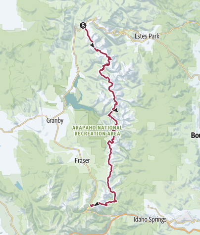
The Pfiffner Traverse is a 77 mile traverse from Berthoud Pass to the Trail Ridge Road.

I thought this was pretty awesome. But I wanted to change things up a bit. I thought it would be great to start and end on a 14’er. So, the obvious choice for this was starting at Gray’s and ending at Long’s.

Now, if you don’t know, much of this route is on the Continental Divide Trail (CDT)…but much of it is off-trail. So, it’s not something that you can just hop on and follow!

Now, this is not to say the resoures for completing the traverse are not available. Andrew Skurka has the definitive guide for the traditional Pfiffner Traverse, and I highly recommend it (see the link above). But since the route I want to take is slightly modified I had to look at some other resources…my favorites being https://www.summitpost.org/ and https://www.14ers.com.